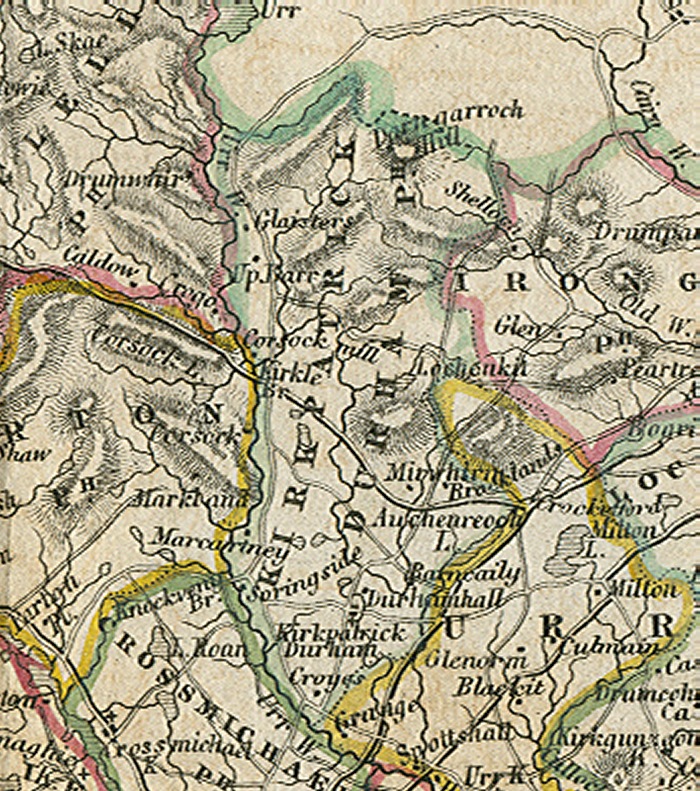
The Parish of Kirkpatrick Durham.
Placenames
The placenames index for this parish is accessed via the menu on the left. Links from there open up access to various historical and modern maps indicating where the place is to be found as well as links to other historical information and photographs if we have them.
References
Extensive historical information, particularly in the form of scanned books, is becoming available on the Internet.
In this section we have begun listing links to this information relative to this parish.
Old Postcards
Thanks to a Victorian hobby of collection topographical postcards many old views from within the parish are available today. This section contains an ever growing
selection from those we have available.
Flickr Galleries
Below the map on the right of this page, there is a series of links to the Flickr website.
Each link gives access to a gallery of images submitted to that website by members of the public on the specified place/topic relating to this parish. We are very grateful to the contributors of the images contained in the galleries for setting permissions for use in this way. They greatly compliment and enhance the content of our website.
A TOPOGRAPHICAL DICTIONARY OF SCOTLAND, by Samuel Lewis. Published in 2 vols, London, 1846.
"KIRKPATRICK-DURHAM, a parish, in the stewartry of Kirkcudbright; containing, with part of the village of Crocketford, 1484 inhabitants, of whom 500 are in the village of Kirkpatrick-Durham, 5 1/2 miles (N. N. E.) from Castle-Douglas. This place derives its name from the dedication of its church to St. Patrick : the adjunct, Durham, distinguishing it from other places of the name of Kirkpatrick, arose from the dry and barren nature of the district in which the parish is situated. On account of its secluded position in the interior of the county, it does not appear to have been connected with any events of political importance; and few particulars of its early history are recorded. In various parts are found remains of circular walls and mounds, called moats ; but from their general character, they seem to have been intended merely as places of security for cattle during the frequent ravages of the border warfare. The Parish is bounded on the west by the river Urr, and is about ten miles in length, from north to south, and nearly four miles in extreme breadth, comprising 20,000 acres, of which 8000 are arable, 500 woodland and plantations, and the remainder hill pasture, moorland, and waste. The surface, though not mountainous, rises gradualy towards the north, and is diversified with cragged hills of considerable elevation, mostly covered with heath, and affording pasturage for sheep and cattle ; the moors in this part of the parish abound with game of every variety, and are much frequented during the shooting season. In the southern districts the surface is comparatively level, gradually subsiding into gentle declivities, and is better adapted for agricultural purposes. The river Urr has its source in Loch Urr, on the western confines of the county of Dumfries, and, flowing southward through a romantic valley, falls into the Solway Frith about ten miles below the southern extremity of the parish. The salmon fishery on this river was formerly very considerable ; but, from the extensive use of stake-nets near the mouth, and from various other causes, it has within the last few years been greatly injured, and very few salmon are now obtained. Herlings, however, are still found in large numbers. There are a few lakes, one of which abounds with trout; but none of them are of any great extent, or distinguished by any interesting features entitling them to particular notice. Various small burns, also, flow through the lands into the river Urr.
The Soil in the lower lands is tolerably good, and, though thin and sandy, is, under proper management, rendered productive, yielding favourable crops of grain : there are, too, some tracts of old pasture which, when brought under cultivation, are luxuriantly fertile. The system of husbandry has been progressively advancing, and is at present quite on a par with what is pursued in the adjacent districts ; but the parish, upon the whole, is rather of a pastoral than an agricultural character, and the farmers rely chiefly on the rearing of black cattle and sheep, of which large numbers are annually sent to Dumfries, Castle-Douglas, and Liverpool. There are some small remains of ancient wood on the lands of Kilquhanity and Kirklebride. The plantations, which are tolerably extensive, are chiefly of modern date, and consist of the usual forest and hard-wood trees, largely interspersed with larch and firs to protect them from the severity of the winds ; they are generally in a thriving state. The rocks are usually of slaty and stratified composition: the substrata exhibit nothing but limestone, in small veins and of very inferior quality, totally unfit for use ; and there are neither mines nor quarries of any kind in operation. The rateable annual value of Kirkpatrick-Durham is £7234. Handsome mansions are scattered throughout the parish, and inhabited by landed proprietors; the principal are, Brooklands, Chipperkyle, Croyes, Doonpark, Durhamhill, Kilquhanity, and Walton Park, all good houses pleasantly situated in grounds tastefully laid out, and embellished with plantations.
The village of Kirkpatrick-Durham is above a mile from the Bridge of Urr. An attempt was made some years since to establish the cotton and woollen manufactures on a small scale, and was for a time attended with success; but they have both been discontinued, and there is no manufacture of any kind carried on here at present. Some of the inhabitants are employed in the usual handicraft trades, and there are several good shops for the supply of the district. A post-office, which has a daily delivery, has been established in the village; and a fair is held annually, on the Thursday after the 17th of March (O. S.), chiefly for plants and garden-seeds, but is not much frequented. Races are held at the time of the fair, which were for a while numerously attended, a course having been formed near the village. In the evening a ball used to take place in some assembly-rooms erected for the purpose, and elegantly decorated : this ball attracted considerable numbers of the people in the surrounding districts. Facility of communication is maintained by the road from the village to CastleDouglas, the great road from Dumfries to Portpatrick, and others which intersect the parish; and by good bridges over the river Urr and its tributaries. About a mile and a half to the south of the village is the pleasingly-rural hamlet called the Bridge of Urr, containing about fifty inhabitants. The village of Crocketford, of which part only is situated within the parish, is described under its own head.
The ecclesiastical affairs are under the superintendence of the presbytery and synod of Dumfries. The minister's stipend is £288. 19. 5., with a manse, and a glebe valued at £10.16. per annum; patron, the Crown. The church, erected in 1748, and enlarged by the addition of an aisle in 1797, is a plain structure near the southern extremity of the parish, containing 374 sittings. A Free church has been erected. There are two parochial schools in the parish : the master of the principal school, in the village, has a salary of £31. 6., with a house and garden, to which is added the interest of a bequest of £270 for the gratuitous instruction of poor children ; and the school fees average about £30 per annum. The master of the other school has a salary of £16. 10., with fees averaging £10. On the lands of Doonpark are some slight remains of an ancient moat, near which were found, a few years since, fragments of old armour; and on the lands of Areeming are the foundations of a church, from which the adjoining farm received the appellation of Kirk-le-Bride. In various parts are the remains of other moats or mounds, of circular form, and apparently constructed for purposes of defence, or as places of security for cattle."