Click map to enlarge
Flickr Galleries
Clatteringshaws ![]()
Loch Trool Reflections ![]()
Glen Trool ![]()
Loch Enoch ![]()
Palnure Burn ![]()
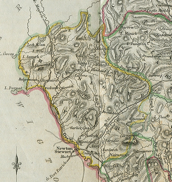
The Parish of Minnigaff.
Placenames
The placenames index for this parish is accessed via the menu on the left. Links from there open up access to various historical and modern maps indicating where the place is to be found as well as links to other historical information and photographs if we have them.
References
Extensive historical information, particularly in the form of scanned books, is becoming available on the Internet.
In this section we have begun listing links to this information relative to this parish.
Old Postcards
Thanks to a Victorian hobby of collection topographical postcards many old views from within the parish are available today. This section contains an ever growing
selection from those we have available.
Flickr Galleries
Below the map on the right of this page, there is a series of links to the Flickr website.
Each link gives access to a gallery of images submitted to that website by members of the public on the specified place/topic relating to this parish. We are very grateful to the contributors of the images contained in the galleries for setting permissions for use in this way. They greatly compliment and enhance the content of our website.
The Parish of Minnigaff. This very large parish is one of considerable contrasts in both landscape and character. The fertile plains along the east bank of the River Cree are low-lying and flat with arable land affording a variety of agricultural uses, but the land in the north of the parish is rugged and hilly with generally poor soil. Of the total area of the parish, only a small proportion of the land is arable, the rest consisting of rough pasture, woodland and waste ground.
The population is small and mainly inhabits the east bank of the River Cree, the principal settlement being the village of Minnigaff. The River Cree forms part of the boundary between the Parishes of Minnigaff and Penninghame, and also the boundary between the former Counties of Wigtownshire and Kirkcudbrightshire. Minnigaff, on the east bank of the River Cree was in Kirkcudbrightshire and Newton Stewart, although only a few hundred yards away, was on the opposite bank of the River Cree, in Wigtownshire. Today, Minnigaff has few facilities that are distinctly its own and to the regret of many of its older inhabitants has become effectively a suburb of the much larger town of Newton Stewart. It does however retain its school, as does the tiny forestry village of Glentrool. Stronord school was converted to an outdoor centre in the late 1960s.
The main sources of employment in the Parish are forestry, agriculture (both hill and dairy farms), and the leisure industry. As in other parts of Galloway, a slow decline in the number of jobs available in agriculture is being compensated for to some extent by the growth of tourism. This is generating an increasing demand for holiday accommodation, some of which eventually becomes full time residences for retired people.
The leisure industry was given an enormous boost in 1947 by the creation of Glentrool Forest Park which consists of 300 square miles of mixed landscape offering rough hillwalking, some rock climbing, and ice climbing in addition to bird watching, camping and mountain biking. The Merrick, though not a Munro is the highest peak in Southern Scotland, and attracts considerable numbers of walkers. The Park is operated by the Forestry Commission, and in 2009 (the International Year of Astronomy), part of it also became the United Kingdom’s first Dark Sky Park. The small population of the area has resulted in very low emission of artificial light, and the operator of the Forest Park has a degree of control over development, making it easier to manage future light emission. Part of the eastern boundary of the parish is formed by Clatteringshaws Loch, formed by the construction of a dam in the 1930s as part of the Galloway Hydro Electric Scheme.
The modern Parish of Minnigaff has become a destination for the increasing numbers of people interested in conservation. The combination of the Forest park, the Dark Skies Park, The Hydro Electric Scheme, and the generally attractive landscape sit very comfortably with the drive to manage a unique environment and provide a specialised tourism experience.
David R. Collin 2010.