Click map to enlarge
Flickr Galleries
New Abbey Village ![]()
New Abbey Village II ![]()
Sweetheart Abbey ![]()
Loch Kinder ![]()
Shambellie House ![]()
Shambellie Costumes ![]()
The Parish of New Abbey.
Placenames
The placenames index for this parish is accessed via the menu on the left. Links from there open up access to various historical and modern maps indicating where the place is to be found as well as links to other historical information and photographs if we have them.
References
Extensive historical information, particularly in the form of scanned books, is becoming available on the Internet.
In this section we have begun listing links to this information relative to this parish.
Old Postcards
Thanks to a Victorian hobby of collection topographical postcards many old views from within the parish are available today. This section contains an ever growing
selection from those we have available.
Flickr Galleries
Below the map on the right of this page, there is a series of links to the Flickr website.
Each link gives access to a gallery of images submitted to that website by members of the public on the specified place/topic relating to this parish. We are very grateful to the contributors of the images contained in the galleries for setting permissions for use in this way. They greatly compliment and enhance the content of our website.
A TOPOGRAPHICAL DICTIONARY OF SCOTLAND, by Samuel Lewis. Published in 2 vols, London, 1846.
"NEWABBEY, a parish, in the stewartry of KirkCudbright; containing 1049 inhabitants, of whom 330 are in the village, 7 miles (S. by W.) from Dumfries. This place, anciently called Kirkindar from the situation of the old church on an island in Loch Kindar, derived its present name from the foundation of an abbey which, in contradistinction to that of Dundrennan, was styled the New Abbey. In 1300, Edward I. of England encamped his army in the immediate vicinity of the abbey, and while here received through the Archbishop of Canterbury a bull from Pope Boniface VIII., rebutting the monarch's claim to the superiority of Scotland, and urging his own title to that kingdom as part of St. Peter's patrimony. Edward held a council at this place, to deliberate upon the pretensions of the pope ; but as the question involved the interests of England, he declined coming to any decision till he should consult with the estates of the realm, for which purpose he disbanded his army, and proceeded to Lincoln, where he summoned a parliament to determine the affair.
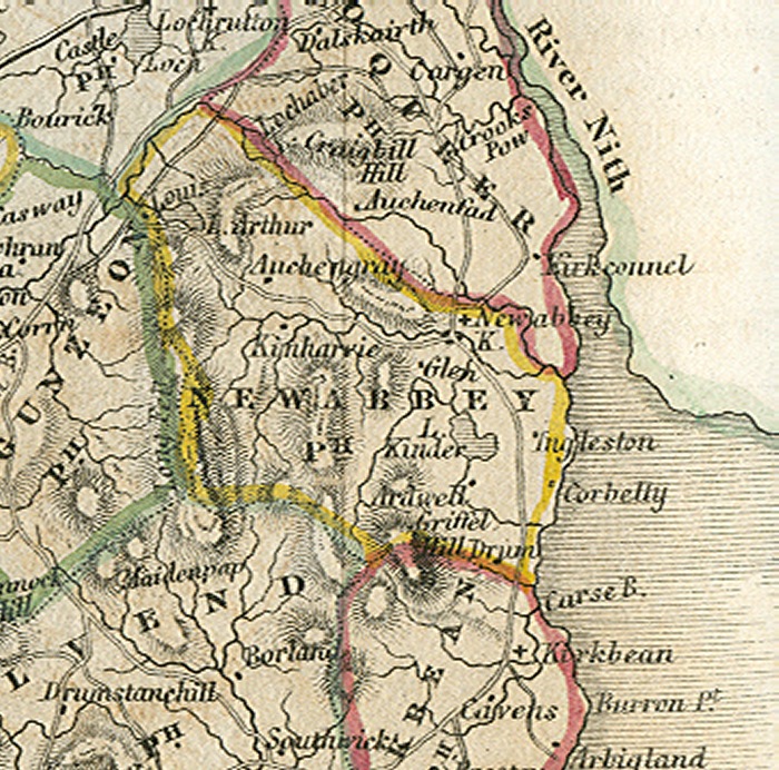
The Parish, which is partly bounded on the east by the river Nith, is about ten miles in length and nearly two miles in average breadth; comprising an area of 11,000 acres, of which 4000 are arable, 600 woodland and plantations, and the remainder hill, pasture, moor, and waste. The surface is greatly diversified. Along the western boundary is a range of hills, of which Lowtis on the north, and Criffel on the south, are the most conspicuous : the higher, Criffel, has an elevation of 1900 feet above the level of the sea. On the north-eastern border is a similar ridge, of less height; between the two ranges is an extensive valley, and towards the south the land has a gentle declivity from the west to the banks of the Nith. The lower lands are watered by numerous small rivulets, rising in various parts of the parish, and which, uniting their streams, form what is called the Pow of Newabbey. There are also three lakes, of which the most extensive is Loch Kindar, near the base of Criffel, about a mile in length and three-quarters of a mile broad, and abounding with different kinds of trout. In this lake are two islands, on one of which are the remains of the ancient parish church, the ruins whereof have been preserved from further decay by a slight repair, and by the fitting up of a part for the accommodation of anglers. Loch End, at the foot of the hill at Lowtis, is three-quarters of a mile in length and half a mile broad, and abounds with perch and pike : near the shore is a small artificial island, richly wooded. Craigend loch, of nearly equal extent with Loch End, from which it is separated by a ridge of rocks, contains pike of large size. The shores of all these lakes are fringed with plantations, and in some parts of them the scenery is beautifully picturesque.
The Soil of the arable lands is generally a gravelly loam, but in some parts clay and moss ; the crops are, grain of all kinds, potatoes, and turnips. The system of husbandry is improved ; the lands have been drained, and inclosed chiefly with fences of stone; the farmbuildings are substantial and comfortable, and on the various farms are eighteen threshing-mills, of which more than one-half are driven by water. The sheep on the hill pastures are of the black-faced breed, but on the low lands chiefly of the Leicestershire, with a few of the Cheviot, which kind has been recently introduced ; the cattle are usually of the Galloway breed. There are considerable remains of natural wood ; and the plantations, which are extensive and in a thriving state, are of oak, ash, beech, larch, and Scotch fir. The rocks in the parish are almost entirely of the sienite formation; there are some veins of coarse limestone and whinstone ; and indications of coal have been observed, but no mines have as yet been opened. The rateable annual value of Newabbey is £4784. On the lands of Shambelly, which have been richly planted, is a handsome house, erected within the last twenty years by William Stewart, Esq., who resides in an ancient mansion in the village ; and a house in the cottage style, on the lands of Kinharvey, has been recently purchased by Mr. Maxwell, of Terregles, as a residence during the shooting season. The village is pleasantly situated on the Pow of Newabbey, near its influx into the Nith, and is neatly built, containing several good houses. There is a parochial library, having a valuable assortment of volumes on history, travels, and divinity ; it has been established for nearly forty years, and is supported by subscription. A hall erected for a Freemasons' lodge, and for the meetings of a friendly society, is now used as a ball-room and for public meetings. A mill for carding and spinning wool, a mill for grain, and a saw-mill, have been erected in the village ; and the timber prepared at the last is generally shipped for Liverpool. An indifferent harbour has been constructed at the mouth of the Pow, which in spring tides is navigable to within a mile of the village for vessels of seventy tons, which land their cargoes of lime and coal for the parish, and return laden with agricultural produce. Salmon, flounders, and herlings are taken in abundance in the Nith, where the inhabitants have the right of fishing, upon paying one-third of what they take to the proprietor, who, however, commutes this payment for a nominal sum of money. A branch of the post-office of Dumfries has been established in the village ; and facility of communication is afforded by good roads which pass through the parish. The small hamlet of Drumburn is pleasantly situated on a burn of that name flowing into the Nith.
The Ecclesiastical affairs are under the superintendence of the presbytery and synod of Dumfries. The minister's stipend is £933, with a manse, and a glebe valued at £33 per annum; patron, the Crown. The church, contiguous to the conventual church of the abbey, of which it originally formed a part, is apparently of the 13th century, and was enlarged in 1805 by rebuilding the front wall; it is in good repair, and contains 470 sittings. A Roman Catholic chapel was built in 1823; but for the last few years no service has been performed in it. There are three parochial schools: the master of the principal school has a salary of £29. 18. 9., with a house and garden, and the interest of a bequest of £150 ; and the masters of the other two have each £10. 13. 10., and one of them the interest of £54. There are still, though greatly dilapidated, considerable remains of the Cistercian abbey already referred to, founded in 1284 by Devorgilla, mother of John Baliol, King of Scotland, who, after the death of her husband, had his heart embalmed, inclosed in a casket of ivory enriched with silver, and deposited in the choir of the church here, from which the abbey took the name of Sweetheart, afterwards changed to that of the New Abbey. The remains consist principally of the conventual church, an elegant cruciform structure in the early English style of architecture, 194 feet in length from east to west, and 102 feet across at the transepts, with a central tower ninety feet high : most of the other buildings were demolished to furnish materials for houses. On the farm of Lundis, about half a mile from the abbey, are the ivy-mantled ruins of a square edifice, the occasional residence of the abbots, near which a metal vessel was dug up a few years since ; and two similar vessels have been found in Loch End, capable of holding from three to four gallons each. Soon after the battle of Waterloo, a granite column fifty feet high was erected on Glen Hill, an eminence in the parish, which has an elevation of 400 feet above the level of the sea, in honour of the Duke of Wellington and the British army, at the suggestion of Robert Johnston, Esq., author of Travels from Petersburgh to Moscow, and along the line of Napoleon's retreat from Russia. On the farm of Craigend is a large rocking stone of sienite, supposed to weigh more than fifteen tons."